Bucegi National Park
The Bucegi Mountains form
a horseshoe shaped ridge oriented from north to south. Its
morphology is given by a hanging plateau deeply carved by
glaciers and by Ialomita river and its tributaries. Whole
structure dips towards the south, from an altitude of 2505m
(Omul Peak) to 1409m (Paduchiosul Peak).
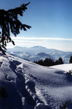
The outer rim of the horseshoe comprises of near-vertical cliffs
which drop up to 1000m, while the inner rim is generally more
gentle. Towers and narrow cricks adorn the abrupt margins,
and glacial circle valleys proceed through small plateaus where
glaciers developed in former times. Waterfalls constitute another
interesting feature of the Bucegi Mts morphology
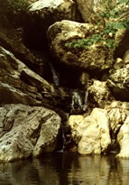
Inside the "horseshoe", Ialomita river cut out gorges
and caves through Jurassic limestones and Cretaceous conglomerates.
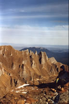
Built of Mesozoic sedimentary rocks (mainly limestones, sandstones
and conglomerate), deformed in the Alpine orogeny and exposed
to erosion since middle Tertiary, the Bucegi Mountains show
its complex origin and evolution recorded in rocks, tectonic
structures (faults and folds) and its morphology.
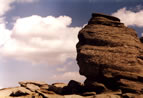
The most recent nature's artwork is the eolian abrasion over
the isolated sandstone cliffs from the top plateau, giving
the "Sphinx" and "Babele" (Old ladies)
sculptures.
Of the 50 types of forestry formations existing in Romania,
12 (24%) exist in the Bucegi National Park. 60% of the Natural
Park’s surface area (19.633 ha) is covered by forests.
The area includes a concentration of 1245 types of spermatophyte
plants. Given the average density of plant species at the national
level, that of the Bucegi region is approximately 250 times
larger. In contrast to equivalent biogeographic regions, this
density is extremely rare and justifies the importance and
major scientific interest given to Bucegi. Here the endemic
element of the Carpathians makes 6 % of the national park’s
flora and represents 91 of the total number of species generally
endemic to the Carpathians.
Habitats:-
Alpine rivers and the herbaceous vegetation along their
banks;
-
Alpine rivers and their ligneous vegetation with Myricaria
germanica;
-
Alpine rivers and their ligneous vegetation with Salix
elaeagnos;
-
Alpine and Boreal heaths;
-
Bushes with Pinus mugo and Rhododendron hirsutum (Mugo-Rhododendretum
hirsuti);
-
Juniperus communis on heath or limestone grasslands;
-
Alpine and subalpine limestone grasslands;
-
Semi-natural dry grasslands and scrublands facies on calcarous
substrates (Festuco Brometalia) (* important orchid sites);
-
Species-rich Nardus grass-lands, on silicious substrates
in mountain areas;
-
Mountain hay meadows;
-
Calcareous fens with Cladium mariscus and species of the
Caricion davallianae;
-
Petrifying springs with tufa formation (Cratoneurion);
-
Alpine pioneer formations of the Caricion bicoloris-atrofuscae;
-
Limestone and calcshist screes of the montane to alpine
levels (Thlaspietea rotundifolii);
-
Limestone rocky slopes with chasmophytic vegetation;
-
Limestone pavements;
-
Luzullo-Fagetum beech forests;
-
Asperulo-Fagetum beech forests;
-
Medio-European limestone beech forests of Cepha-lantheron-Fagion;
-
Alluvial forests with Alnus glutinosa and Fraxinus excelsior
(Alno-Padion, Alnion incanae, Salicion albae);
-
Acidophilous Picea forests of the montain to the alpine
levels (Vaccinio-Piceetea);
-
Alpine Larix decidua and/or Pinus cembra forests. Endemic
Larix deciduas ssp. Carpatica
Some data was taken from Center
for Mountain Ecology – Moeciu
de Sus
|